

Gamuda transforms project delivery with ArcGIS
The increasing complexity of infrastructure projects has resulted in a need for real-time collaboration, streamlined site planning, and effective progress tracking. In turn, architecture, engineering, and construction (AEC) organizations are often faced with diverse data sources and formats, making data management a formidable challenge throughout a project’s life cycle.
Gamuda Engineering Sdn Bhd, a regional engineering, property, and infrastructure company based in Malaysia, has transformed project delivery and operational efficiency through a groundbreaking digital transformation initiative. The company has accomplished this by implementing an enterprise-wide geographic information system (GIS) solution to support project collaboration and delivery. This sophisticated implementation spans multiple global regions and represents a significant advancement in engineering and construction data management and utilization.
Key Takeaways
- Gamuda Engineering Sdn Bhd transformed project delivery and operational efficiency through a groundbreaking digital transformation initiative.
- Implementation of ArcGIS Enterprise in the Microsoft Azure Cloud provided scalability, flexibility, and real-time access to project information. Custom web applications and mobile GIS tools enhanced field operations, reducing design errors and improving collaboration.
- The successful implementation of ArcGIS has established Gamuda as a technology leader in the AEC sector, enhancing project delivery and operational efficiency, and providing a blueprint for other organizations.
Overcoming Disparate Data and Integration Challenges
Infrastructure projects typically involve the complex task of integrating multiple data sources from various stakeholders, such as geotechnical surveys, utility mappings, and site plans. These complex datasets, often in different formats and from multiple stakeholders, needed to be consolidated in a seamless way for tendering new projects and project delivery.
“With ArcGIS Enterprise, we’ve been able to break down data silos and create a centralized, real-time view of our projects across different regions. This integration has significantly improved communication between teams and stakeholders, enabling better visualization of project datasets, faster decision-making, and more efficient project execution,” said Wan Hamizi Bin Wan Taha, GIS manager at Gamuda.
Real-time collaboration also emerged as a critical challenge, particularly as project teams worked across multiple geographic locations. Traditional methods of site planning and progress tracking couldn’t keep up with the scale and complexity of Gamuda’s projects. Further, integrating GIS and building information modeling (BIM) data presented technical hurdles that needed to be overcome to support comprehensive decision-making processes.
Gamuda’s solution leveraged a dual deployment of ArcGIS Enterprise in the Microsoft Azure Cloud environment, which provides the fundamental spatial data management capabilities. This is complemented by ArcGIS Pro for advanced desktop analysis and data preparation. The primary ArcGIS Enterprise deployment in Singapore supports Malaysian operations, while a secondary deployment in Sydney supports Australian projects. This distributed architecture ensures optimal performance and data sovereignty compliance across different global regions.
“Our cloud-based ArcGIS Enterprise deployment on Azure has been fairly easy,” continued Wan Hamizi. “We’ve experienced excellent scalability and flexibility, which allows us to meet the evolving demands of large, data-intensive projects. Deploying cloud-based ArcGIS Enterprise offers high availability, ensuring reliable performance and reduced downtime.”
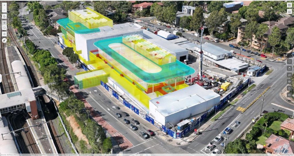
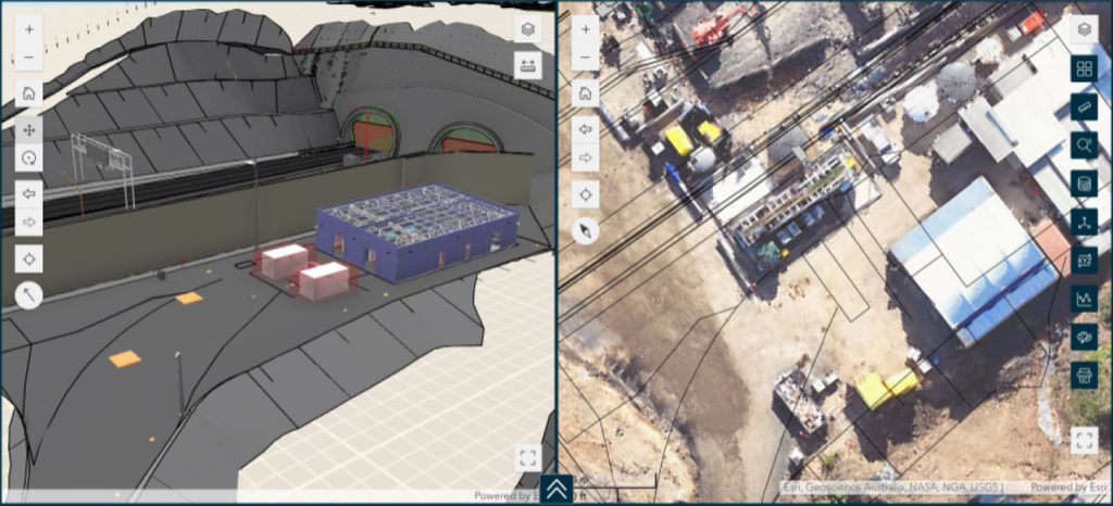
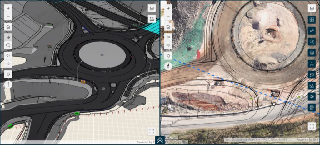
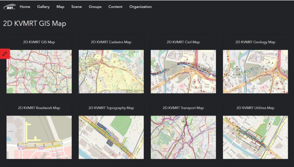
The system integrates multiple data streams through custom-configured web applications built using ArcGIS Experience Builder. These applications provide dynamic 2D and 3D visualization capabilities, used by teams and stakeholders for evaluation and decision-making. The data integration components incorporate multiple sources through standardized protocols. The data outputs are then published and compiled into custom web-based applications created with ArcGIS Experience Builder and tailored to specific project needs and personas.
“Our Experience Builder apps offer features like interactive 2D and 3D visualizations, which provide project teams with a dynamic view of our data and also offer spatial context for BIM models,” said Wan Hamizi. “Off-the-shelf widgets like Layer, Legend, Search, Print, Bookmark, and Pop-Ups are implemented by default. We also develop our own customized tools like TRANSIT (Traffic Management System), Digital Permits, AGS Viewer tool, Cross Section Viewer tool, Utilities Relocation tool, and Land Delivery Management tool, depending on the needs of the project.”
Government open data is integrated through REST APIs, while high-resolution satellite imagery from providers such as Nearmap, MetroMap, and Planet is incorporated through secure image services. A crucial technical achievement was the successful integration with Autodesk Construction Cloud (ACC), enabling seamless GIS and BIM data synchronization.
A Leader in the AEC Sector with Advanced GIS Solutions
The deployment of ArcGIS Enterprise has fundamentally transformed Gamuda’s project delivery methodology. The system now serves as a central platform for spatial data management, enabling real-time access to critical project information through web-based portals and services. These portals provide sophisticated visualization capabilities, allowing teams to analyze both 2D and 3D data simultaneously.
“Integrating GIS and BIM has had a transformative impact on our preconstruction, design, and planning processes. GIS provides spatial context that complements the detailed design data in BIM, giving us a more holistic view of our projects,” said Wan Hamizi. “This integration has led to better visualizations, better-informed decision-making, reduced design errors, and improved collaboration with stakeholders.”
Field operations have been revolutionized through the implementation of mobile GIS applications. The deployment of ArcGIS Field Maps, ArcGIS Survey123, and ArcGIS QuickCapture has created a robust mobile data collection system. Field teams now capture site photographs and conditions with precise spatial references, enabling immediate integration with ArcGIS Enterprise.
“Survey123 and QuickCapture have significantly improved our field data collection process, allowing our field teams (non-GIS literate users) to easily capture and share real-time data directly from the site,” shared Wan Hamizi.
The technical architecture supports advanced spatial analysis capabilities, allowing project teams to perform complex geospatial queries and analyses. This has particularly enhanced site planning processes, where multiple layers of information—from subsurface utilities to aboveground structures—can be analyzed simultaneously.
“We are also exploring opportunities to leverage GIS for ESG [environmental, social, and governance] initiatives, such as managing environmental impact assessments and monitoring progress on green building efforts . . . Additionally, we plan to continue expanding our use of 3D modeling and immersive technologies like AR/VR to improve project design and stakeholder engagement further,” said Wan Hamizi.
Gamuda’s implementation of an enterprise GIS represents a significant advancement in the AEC sector’s digital transformation journey. This modern spatial intelligence solution demonstrates how cloud-based GIS technology can be leveraged to create a comprehensive spatial data infrastructure that supports complex project delivery requirements.
The successful implementation of this technology has established Gamuda as a technology leader in the AEC sector. This showcases how sophisticated spatial technology can be effectively deployed to enhance project delivery and operational efficiency. As projects continue to evolve, enterprise GIS deployments provide a blueprint for other AEC organizations seeking to leverage spatial technology for complex infrastructure projects.