

Managing traffic from a bird’s eye view
Unprecedented data use will guide safety, compliance and traffic management for Penang’s Mutiara LRT during construction
Many cities in the world grapple with managing road traffic congestion, and the urbanised parts of Penang are no exception, especially the stretch between the Bayan Lepas Free Industrial Zone (FIZ) and Komtar on Penang island side.
In the morning and evening rush hours, traffic flow on the two bridges linking the island with the mainland is heavy, while the passenger ferry service is packed to the brim.
This “normal” flow will soon be disrupted by the commencement of construction activities for the upcoming Mutiara Line project, a 29.5km LRT system with 21 stations that connects key areas of Penang Island and the mainland.
As construction will necessitate some traffic diversions, or the taking away of a lane or two from a multiple-lane road, normal traffic flow will be impeded at some parts of the island.
The task of building the first phase of the LRT stretching from Silicon Island, near the Penang International Airport (PIA), all the way to Komtar, has been given to SRS Consortium, where Gamuda Bhd holds a 60% interest.
SRS Consortium general manager Mohd Faiz Daud said while engineers have experience building metros through urban areas such as the Kajang MRT and Putrajaya MRT in Kuala Lumpur and Selangor, replicating the same in Penang does not mean that it is a walk in the park.
This is because most of the alignment of the Mutiara LRT goes through what are highly built-up areas, some with heritage value, such as areas around Komtar and Magazine Road in George Town, which has been identified as one of the traffic hotspot areas when construction starts.
“The other two places where traffic congestion is expected to be severe, as gleaned from current data, are the Sunny Point junction (where Jalan Sultan Azlan Shah meets Jalan Sungai Dua and Jalan Batu Uban), and the meeting point between Jalan Sultan Azlan Shah and Jalan Tengah.
“As a good part of the alignment will actually be built along road median, it means the two lanes – one on each side – next to the road median will have to be closed during construction,” said Mohd Faiz, who added that where possible, affected roads will be widened first before the lane next to the median is closed off for construction.
Having worked on both the Kajang and Putrajaya MRT projects in the Klang Valley, Mohd Faiz is not taking anything for granted in Penang.
“It is a different environment, different demographics, with very limited space,” he said, adding that the intent to minimise land acquisition means that the road median will be used wherever feasible.
The only “greenfield” the contractor has is parts on the newly-reclaimed Silicon Island, which will have a passenger station and train depot, as well as the alignment to the first station at Permatang Damar Laut nearby. From that point on towards Komtar, it is a challenging environment as there will not be any greenfield.
Robust data collection and analysis
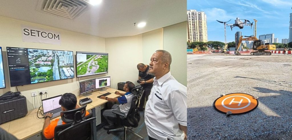
To ensure that traffic can still flow reasonably well, SRS has been collecting comprehensive traffic information using enumerators on the ground, as well as a fleet of drones to monitor traffic.
“People will be seeing a lot of drones over the LRT alignment over the next few years.
“This is not something to worry about as it is part of project management,” said Adil Putra Ahmad, SRS Consortium Sdn Bhd’s project director, adding that the drone operators are licensed to operate the devices.
“We are fully compliant with the regulations of the Civil Aviation Authority of Malaysia (CAAM) and the Survey and Mapping Department (Jupem). Our drones will not hover more than 120m above ground, and will observe the no-fly-zones around the airport.
“With safety as top priority, the drones will also be grounded during bad weather,” he said.
The drones will provide real-time monitoring to identify congested areas, monitor traffic patterns and detect potential bottlenecks.
“When it comes to quick assessment of abnormal events like accidents, drones can reach the sites faster to assess the situation to assist emergency responders,” he said, adding that drones also help in the identification of hazards like debris and stalled vehicles, thus allowing for prompt intervention.
Cross-agency information sharing with Big Data
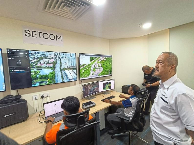
The integration of these aerial monitoring data and other information will be done at the Surveillance, Enforcement and Traffic Command Centre (SETCOM), a purpose-built facility housed within SRS’s headquarters in Bukit Jambul, Penang.
According to Adil Putra, SETCOM will be critical in providing information to enable rapid response to investigate abnormal traffic buildup and help the relevant agencies and local authorities respond accordingly along with SRS’s on-ground teams.
One hazard that SETCOM has identified is the presence of flash floods (not necessarily connected with LRT work), and here, aerial monitoring helps immensely, especially when paired with proposed on-ground sensors to detect rising water levels.
“Flash floods are quite common, and we know where the flood prone areas are, and we are developing a prototype that will alert us of impending flash floods to be used for this project.
“We use a lot of technology to help in planning,” said Adil Putra, adding that there will be close collaboration with agencies like the Fire and Rescue Department and Penang Island City Council.
“We are also in discussions with the Malaysian Highway Authority, the Public Works Department and the traffic police as part of information sharing.
“With feedback from government agencies, and by putting all layers of data together, we can analyse and put it to use,” he said about the comprehensive way of how SRS’s data-driven approach will enable authorities to make informed decisions about traffic signal timing and rerouting.
“We are also working with Waze so that the app can also show to its users where work is ongoing so that vehicles can be routed appropriately. This discussion took quite a while.”
Short-term pain for long-term gain
Other mitigation measures include dialogues with large employers in Penang such as member companies of The Free Industrial Zone, Penang, Companies’ Association (better known as Frepenca) to possibly stagger the arrival and departure of their workers’ buses to the FIZ so that traffic can also be better managed.
On the contractor’s part, it will also time its activities such as the movements of heavy vehicles to take place during non-peak hours, as far as possible, along with continuous engagement of stakeholders.
The Mutiara Line LRT will see simultaneous construction on the whole alignment, with full passenger service expected by the end of 2031.
Traffic consultants say that while the project takes five years, it does not equate to five years of non-stop traffic misery.
According to Adil Putra, depending on each site, road diversions will be done in stages, so it will not be a case of the entire island being gridlocked for years on end.
“It will be more likely three years of intense work, before things return to normalcy. Some parts will reopen earlier, and it is not a situation where the entire island is being disrupted all at once, and continuously, for five years.
“Affected roads will reopen as soon as possible. We hope Penangites will bear with this, and I believe the people will be able to handle this for the sake of long-term gain.”